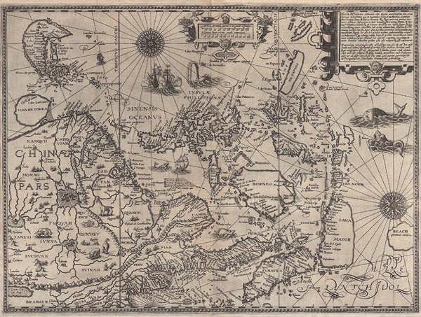
Exacta & accurata delineatio cum orarum maritimarum tum etiam locorum terrestrium quae in regionibus China, Cauchinchina, Camboja sive Champa, Syao, Malacca, Arracan & Pegu...

A mű címe
Exacta & accurata delineatio cum orarum maritimarum tum etiam locorum terrestrium quae in regionibus China, Cauchinchina, Camboja sive Champa, Syao, Malacca, Arracan & Pegu...
Rare, first published map of Southeast Asia, oriented unusually: with north to the left. It is emblematic to the end of the Portuguese monopoly on the East Indian trade and was among the most important sources of information on the region during the 16th century. The cartographer -- mostly based on Portuguese sources -- shows Korea as an island and a geographically strange representation of Japan. Jan Huygen van Linschoten used manuscript maps from several origins: Southeast Asia and Japan are based on the cartography of Fernăo Vaz Dourado, China on the map of Luis Jorge de Barbuda, the Philippines is taken from Bartolomeu Lasso and in the case of the other regions he relied on the reports of Marco Polo (and this explains the location of the mythical land of "Beach provincia aurifera" the
Auction 141 / 180.

Starting price: HUF 900 000
Hammer price: HUF 1 500 000

Délkelet-Ázsia elsőként megjelent, ritka, kelet-nyugati tájolású, rézmetszetű térképe (Amszterdam, 1595). Jan Huygen van Linschoten „Itinerario” című munkájában adta közre. A lap nemcsak a portugál kelet-indiai kereskedelmi monopólium végét jelképezi, hanem egyike a terület legfontosabb, XVI. században fellelhető bemutatásának. A mű – főként portugál forrásokra támaszkodó – készítője Koreát szigetként ábrázolta, és Japánt is feltünteti, bár a jelenlegi földrajzi ismereteink birtokában kissé értelmezhetetlenül. Van Linschoten Délkelet-Ázsia és Japán domborzatának és partvidékének megrajzolásához Fernăo Vaz Dourado, Kína megjelenítéséhez Luis Jorge de Barbuda, a Fülöp-szigetek bemutatásánál Bartolomeu Lasso kéziratos térképeit vette alapul, a többi régiót pedig Marco Polo leírásaira hagyatkozva alakította ki (ezért szerepel benne a „Beach provincia aurifera”nevű mitikus sziget nagyjából ott, ahol később Ausztráliát felfedezték). A metsző – Henricus van Langern – munkáját őshonos állatokkal, tengeri szörnyekkel, hajókkal és két csodaszép szélrózsával illusztrálta, a címet illetve a térképészeti adatokat díszes kartussal övezte. Mérete: 395 x 530 mm. Paszpartuban.

Rare, first published map of Southeast Asia, oriented unusually: with north to the left. It is emblematic to the end of the Portuguese monopoly on the East Indian trade and was among the most important sources of information on the region during the 16th century. The cartographer — mostly based on Portuguese sources — shows Korea as an island and a geographically strange representation of Japan. Jan Huygen van Linschoten used manuscript maps from several origins: Southeast Asia and Japan are based on the cartography of Fernăo Vaz Dourado, China on the map of Luis Jorge de Barbuda, the Philippines is taken from Bartolomeu Lasso and in the case of the other regions he relied on the reports of Marco Polo (and this explains the location of the mythical land of "Beach provincia aurifera" the region where Australia would eventually be discovered). The map was beautifully engraved by Langren with richly decorated cartouches and illustrated with a number of native animals, sea monsters, ships and two gorgeous compass roses. Published in van Linschoten "Itinerario" (Amsterdam, 1595).
Dimensions: 395 x 530 mm.