A mű címe
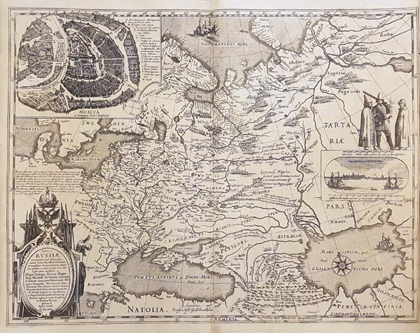
Tabula Russiae ex autographo, quod delineandum curavit Foedor filius Tzaris Borois desumta… MDCXIIII
angol szoveg
1632 issued, copper engraving map of Russia -- with large inset of Moscow and view of Arkhangelsk -- by Hessel Gerritsz. The original map is attributed to Fyodor II Borisovich Godunov, who was briefly the tsar of Russia. Following Gerritsz’s death, Willem Blaeu issued an edition of the map. Over the martial cartouche, at the top left corner the inset plan of Moscow can be found with a 17-point location key. This plan first appeared in print on the present map and had been used for decades. To the right of the map is a view of Arkhangelsk – with three figures in Russian clothes standing above –, which was the only sea gate of Russia before the foundation of St. Petersburg.
Dimensions: 430 x 550 (455 x 560) mm.
Dimensions: 430 x 550 (455 x 560) mm.
Oroszország Hessel Gerritsz által készített rézmetszetű térképének 1632-es, amszterdami kiadása. Az eredeti térkép készítőjének Fjodor II. Boriszovics Godunovot tartják, aki rövid ideig Oroszország cárja volt. Gerritsz halála után a nyomólemez Willem Janszoon Blaeu tulajdonába került, aki a Fekete-tenger alatti impresszumot megváltoztatva adta ki. A díszes kartus fölött, a lap bal oldalán Moszkva melléktérképen látható, a főbb épületek megjelölésével. Jobb oldalon az arhangelszki kikötő (fölötte három, orosz viseletbe öltözött alakkal), amely Szentpétervár megalapítása előtt Oroszország egyetlen tengeri kapuja volt. Mérete: 430 x 550 (455 x 560) mm. Paszpartuban.
