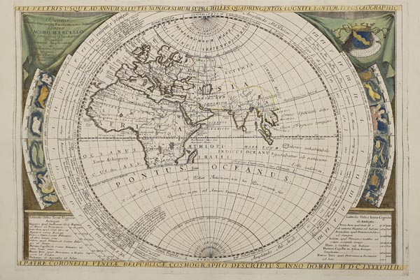
Planisfero Del Mondo Nuovo Descritto -- Aevi Veteris Usque Ad Annum Salutis Nonagesimum Supra Milles Quaringentos Cogniti Tantum Typus Geographic.
VelenceAuction 152 / 175.
Starting price: HUF 600 000Kétlapos, kézzel színezett világtérkép, amely Vincenzo Maria Coronelli „Atlante Veneto” című munkájában jelent meg (lásd előző tételünket).
A nyugati félteke ábrázolása a kor legfrissebb forrásait – többek között Abel Tasman ausztráliai felfedezéseit – felhasználva született meg, így megfigyelhető rajta Új Zéland és Új Guinea partvidékének korai képe. Felbukkannak azonban a kor kartográfiai tévedései is, mint az Anian-szoros és a Terra di Iesso. Kalifornia különálló szigetként, Ázsia és Japán furcsa alakú partvonallal jelenik meg.
A keleti félgömb megjelenítése a klasszikus térképészek (Ptolemaiosz, Sztrabón és Pomponius Mela) műveiből táplálkozik. Látható Európa, az afrikai kontinens és Ázsia nagy része, de teljesen hiányzik róla Japán, Kína és Ázsia északkeleti régiója.
Mindkét lap keretdíszében a csillagjegyek ábrái, több koordinátákkal kapcsolatos információ és egy-egy ajánlás (Jacopo és Andrea Marcello részére) kapott helyet.
For the depiction of the Western hemisphere the most recent sources of the age – like Abel Tasman’s Australian discoveries among others – had been used, therefore, the early coastline of New Zealand and New Guinea can be observed. Nevertheless, the contemporary cartographical mistakes of the age are also present such as the Anian Strait or the Terra di Iesso, California is represented as a separate island, and Asia and Japan have a strangely shaped coastline.
The representation of the Eastern hemisphere builds on the works of the classical cartographers (Ptolemy, Strabo and Pomponius Mela). Europe, Africa and a large part of Asia are visible, but Japan, China and Asia’s northeastern region are completely missing.
In the frames of both sheets, the pictures of the Zodiac signs, various, coordinates-related information and dedications (to Jacopo and Andrea Marcello) can be found.
Dimensions: 470 x 620 (490 x 670) mm. 2 fine, clear, coloured sheets.

