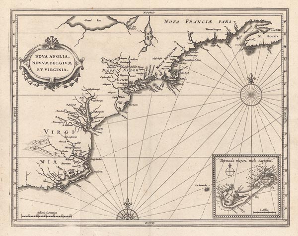
Nova Anglia, Novum Belgium et Virginia.
1630 LeidenAuction 143 / 179.
Starting price: HUF 800 000 Hammer price: HUF 800 000Hessel Gerritsz által készített, ritka, rézmetszetű térkép, amely Új-Skóciától Virginiáig mutatja be Észak-Amerika keleti partvidékének középső részét, kiegészítve a Bermuda-szigetcsoport melléktérképével. Johannes de Laet fő művének második — Beschrijvinghe van West-Indien… című — kiadásában jelent meg. Térképészeti mérföldkőként, a gombamódra szaporodó holland és az angol települések — többek között Manhattan (Manbattes), az 1626-ban alapított New York (N. Amsterdam), Albany (Fort Orange) és Massachusetts (az akkoriban alapított angol kolónia) — említésének első, nyomtatásban megjelent emléke és egyike a Nagy Tavak (Grand Lac és Lac des Yroquois), a Hudson (Noordt Rivier) és a Delaware (Zuyd Rivier) folyó korai ábrázolásainak. A munkát készítője a szárazföld belsejébe helyezett, növényi ornamensekkel díszített kartussal és két szélrózsával illusztrálta. Ahogy Philip D. Burden bibliográfiájában kifejti: "Hessel Gerritsz — aki feltehetően metszője is a lapnak — a Holland Kelet-Indiai Társaság hivatalos térképészeként hozzáférhetett holland utazók Hudson-folyóról készített térképeihez és útleírásaihoz. A Chesapeake-öböl és a Cape Cod közötti partvidék ábrázolása messze a legpontosabb, annak ellenére, hogy e szerint a Delaware-folyó egy tóból ered." Johannes de Laet a Holland Nyugat-Indiai Társaság igazgatójaként szintén sok, a telepesek által nyújtott információhoz, illetve korabeli felmérések adataihoz jutott hozzá, így magyarázható a kora színvonalát meghaladó mű születése.
Mérete: 285 x 360 (335 x 405) mm.
Paszpartuban.
As Philip D. Burden writes in his bibliography: „Hessel Gerritsz, the author and probable engraver of the map, had been the official cartographer to the Dutch East India Company since 1617. He would have seen all the documentation and charts from the Dutch voyages into the area of the Hudson River. His depiction of the coastal area between Chesapeake Bay and Cape Cod is by far the finest yet seen. This despite the fact that he still shows the Delaware River flowing from a lake.”
Johannes de Laet – the publisher – as the director of the Dutch West India Company was also able to collect lots of information from the settlers and data from the contemporary surveys, which explains the birth of this fine map exceeding the standard of its time.
Dimensions: 285 x 360 (335 x 405) mm.
