Ugrás a tartalomra

Americae Pars Borealis, Florida, Baccalaos, Canada, Corterealis.

A mű címe
Americae Pars Borealis, Florida, Baccalaos, Canada, Corterealis.
De Jode’s rare map of North America was prepared for the second edition of Speculum Orbis Terrarum (Antwerp, 1593), and it is the first full folio size atlas map to focus on this region. Although De Jode’s map was a vastly superior map to Ortelius’ „Americae Sive Novi Orbis Nova Descriptio”, his atlas sold poorly and this is the reason for the comparative rarity of de Jode’s maps today. The map includes many truly striking details like the dual Northwest Passage and the course of the St. Lawrence River, flowing across the continent from Texas to the Pacific Ocean. Besides de Jode had also enriched the presentation of the New World with notes of the early explorers (Verazano, Cabot, Raleighand), with a battle scene in the upper right corner and with illustrations of native Indians at the bo
141. árverés / 178.

Kikiáltási ár: 5 000 000 Ft
Leütési ár: 5 000 000 Ft

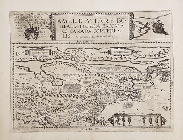
Cornelius de Jode Speculum Orbis Terrarum című művének második kiadásához (Antwerpen, 1593) készült – kizárólag ebben szereplő – rézmetszetű Észak-Amerika térkép. A terület első folio-méretű atlaszban megjelent ábrázolása. Bár de Jode térképe sokkal jobb volt az Ortelius-féle „Americae Sive Novi Orbis Nova Descriptio”-nál, az általa összeállított atlasz kevésbé volt kelendő, ezért munkái napjainkban sokkal ritkábban bukkannak elő. A bámulatra méltóan részletes térkép mai tudásunk tükrében kissé merész elképzeléseket is tartalmaz, így egy kettős északnyugati átjárót, és a Texastól az Atlanti-Óceánig futó Szent Lőrinc folyót. De Jode ezen kívül kora felfedezőinek (Verazano, Cabot, Raleighand) jegyzeteivel, a jobb felső sarokban egy harci jelenettel, alul pedig indiánokat bemutató illusztrációval is gazdagította az Újvilág bemutatását. Mérete: 370 x 510 (430 x 575) mm. Paszpartuban.

De Jode’s rare map of North America was prepared for the second edition of Speculum Orbis Terrarum (Antwerp, 1593), and it is the first full folio size atlas map to focus on this region. Although De Jode’s map was a vastly superior map to Ortelius’ „Americae Sive Novi Orbis Nova Descriptio”, his atlas sold poorly and this is the reason for the comparative rarity of de Jode’s maps today. The map includes many truly striking details like the dual Northwest Passage and the course of the St. Lawrence River, flowing across the continent from Texas to the Pacific Ocean. Besides de Jode had also enriched the presentation of the New World with notes of the early explorers (Verazano, Cabot, Raleighand), with a battle scene in the upper right corner and with illustrations of native Indians at the bottom.
Dimensions: 370 x 510 (430 x 575) mm.