Ugrás a tartalomra

Totius orbis cogniti universalis descriptio

A mű címe
Totius orbis cogniti universalis descriptio

141. árverés / 177.

Kikiáltási ár: 3 500 000 Ft
Leütési ár: 3 500 000 Ft

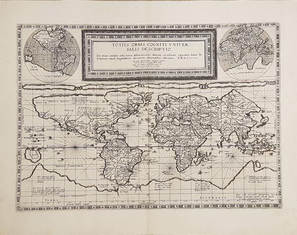
Téglalap vetületű rézmetszetes világtérkép, a keretezett kartus két oldalán -- a lap felső sarkaiban -- egy-egy félgömb-ábrázolással. A lap jobb alsó sarkában található leírás szerint Cornelis de Jode készítette 1589-ben, a Douai-i egyetemen, a bal oldalon -- kiadóként -- pedig az apja, Gerard neve áll. Atlaszban történő közzététele több évet váratott magára, hiszen a Speculum Orbis Terrarum 1593-as, második kiadásában jelent csak meg. Shirley szerint a szokatlan vetületi ábrázolás ötletét Marinosztól, a felhasznált földrajzi elemeket Mercatortól és Ortelius-tól eredeztetik. Mercator hatása teljesen tisztán felismerhető, hiszen az 1569-es világtérképén megjelenített északnyugati és északkeleti átjáró, a hatalmas kiterjedésű ismeretlen déli földrész, a "Terra Australis" szinte teljesen megegyezik, és a két munka poláris kialakítása is hasonló. Mérete: 350 x 505 (440 x 570) mm. Paszpartuban.

Rectangular projection world map with framed cartouche, and two small hemisphere maps in the upper corners. Appeared only in the second — and final — edition of de Jode's Speculum Orbis Terrarum, published in 1593. There is a note in the lower right-hand corner of this map stating that Cornelis de Jode made the map in November 1589 at the Academy of Douai and the printer's signature is that of Cornelis' father, Gerard. According to Shirley, the map is generally attributed to Marinus of Tyre, with geography based on Mercator and Ortelius. Impact of Mercator is clearly recognizable since the Northwest and Northeast Passage, the massive unknown southern continent — the "Terra Australis" — and the similar polar configuration derive from Mercator's World map of 1569.
Dimensions: 350 x 505 (440 x 570) mm.