Ugrás a tartalomra

Nova, et Integra Universi Orbis Descriptio

A mű címe
Nova, et Integra Universi Orbis Descriptio
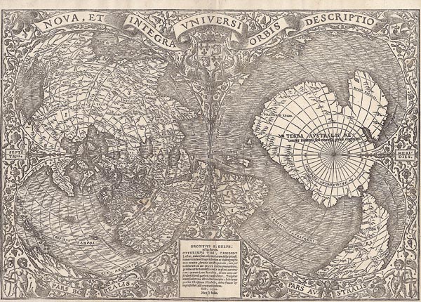
1540 Párizs, First edition of the famous double-cordiform map by Oronce Finé. Published in the 1531 Paris edition of Novus orbis regionum. He was the first to apply the double-cordiform visualization and this was the first instance for the use of the polar projection in the history of cartography as well. The use of the strange projection – and the impact of Finé – can be observed on Mercator’s world map from 1538, and later on the works of Lafreri up until the end of the 16th century (de Jode). Although Finé included the latest discoveries -- he first used the name of Magellan in cartographical context (Mare magellanicum) -- he still follows Ptolemy. The northern hemisphere involves an eye-catching mistake: Asia and North America is not separated, what is more, North America appears to be a peninsula
141. árverés / 172.

Kikiáltási ár: 6 000 000 Ft
Leütési ár: 10 000 000 Ft

Oronce Finé – a XVI. századi jeles francia térképész – híres, kettős szív alakú vetületeket ábrázoló, fametszetű világtérképének első kiadása. A Párizsban, 1531-ben – a Novus orbis regionum című atlaszban – megjelent munka több tekintetben is egyedi megoldásokat alkalmazott. Elsőként használta a térképészet történetében a – bonyolult geometriai számítások alapján megrajzolt – kettős szív alakú megjelenítést és a poláris vetületeket. A furcsa vetület alkalmazása – és Finé hatása – megfigyelhető Mercator 1538-as világtérképén, később pedig Lafreri de Jode művein egészen a XVI. század végéig. Bár térképe készítésénél Finé a legújabb felfedezésekre is támaszkodott – így ő használta Magellán nevét (Mare magellanicum) először térképészeti megjelölésként – még továbbra is a ptolemaioszi utat követi. Az északi félgömbön egy térképészeti tévedés figyelhető meg: Ázsiát és Észak-Amerikát nem választja szét (Észak-Amerika csupán egy Ázsiából kinyúló félszigetnek tűnik). A déli félgömb jelentős részét elfoglaló kontinensre írt – az elnevezést kiegészítő – szöveg „Terra Australis recenter inventa, sed nondu[m] plene cognita” (a közelmúltban felfedezett, de még nem teljesen ismert déli földrész) pedig a későbbi korokban találgatások tömegét indította el, hiszen az Antarktisz hivatalos felfedezése előtt 289 évvel született. Mérete: 290 x 415 (305 x 420) mm. Paszpartuban.

First edition of the famous double-cordiform map by Oronce Finé. Published in the 1531 Paris edition of Novus orbis regionum. He was the first to apply the double-cordiform visualization and this was the first instance for the use of the polar projection in the history of cartography as well. The use of the strange projection – and the impact of Finé – can be observed on Mercator’s world map from 1538, and later on the works of Lafreri up until the end of the 16th century (de Jode). Although Finé included the latest discoveries — he first used the name of Magellan in cartographical context (Mare magellanicum) — he still follows Ptolemy. The northern hemisphere involves an eye-catching mistake: Asia and North America is not separated, what is more, North America appears to be a peninsula protruding from Asia. The southern hemisphere is dominated by the large continent labelled "Terra Australis recenter inventa, sed nondu[m] plene cognita" (southern land recently found, but not yet fully known) and this comment had caused a mass of speculations in the following ages since the map was born 289 years before the official discovery of Antarctica.
Dimensions: 290 x 415 (305 x 420) mm.