Ugrás a tartalomra

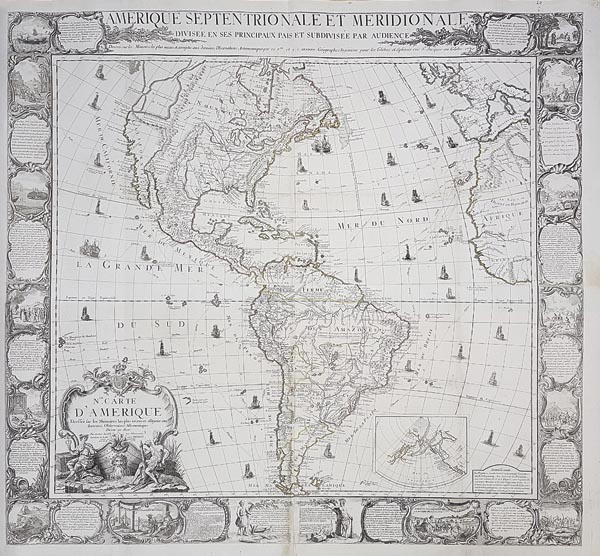
N[ouvel]le. carte d'Amerique: dressée sur les mémoires les plus récens et assujetie aux derniers observations astronomiques

A mű címe
N[ouvel]le. carte d'Amerique: dressée sur les mémoires les plus récens et assujetie aux derniers observations astronomiques
Decorative wall map of America with inset map of Northern Pacific by Louis-Charles Desnos, from Paris, 1781. Additional title at top: „Amerique Septentrionale et Meridionale, Divisée en ses Principaux Pais et Subdivisée par Audience... 1770”. The highly ornate border panels present scenes from American history and life – depicting the early discovery of America and subjugation of the indigenous peoples – with descriptive text. In the Atlantic and Pacific Oceans the routes of major explorers and circumnavigators (Columbus, Magellan, Vespucci) are shown with vignettes of early sailing ships. Cartographically, the most curious feature of the map is the depiction of the Sea of the West (also called the Bay of the West). The source of the modern legend was a manuscript map by Guillaume De L’Is
141. árverés / 185.

Kikiáltási ár: 3 000 000 Ft
Leütési ár: 3 000 000 Ft

Amerika Louis Desnos által készített rézmetszetű fali térképe (Párizs, 1781), a Csendes-óceán északi részének melléktérképével. A XVIII. század végén divatos dekorációnak is számítottak a kartográfiai munkák, ezért egyre több, nagy méretű, falra szánt lapot adtak ki, amelyek arisztokraták könyvtárait, szalonjait díszítették. Desnos ezt az igényt kívánta kielégíteni a gazdagon díszített művel, amely először 1770-ben jelent meg. A térképet övező rendkívül dekoratív keretben felül a térképlap kiegészítő címe (Amerique Septentrionale Et Meridionale Divisee En Ses Principaux Pais Et Subdivisee Par Audience… 1770), körben amerikai történelmi és életképek (többek között a kontinens felfedezése, az indiánok leigázása), valamint az ezeket bemutató szövegek sorakoznak. Az Atlanti- és a Csendes-óceánt a világot körülhajózó nagy felfedezők (Kolumbusz, Magellán, Vespucci) útvonalai szelik át és hajók illusztrációi díszítik. Földrajzilag a legfurcsább jellemzője a „Nyugati-tenger” (más néven a Nyugati-öböl) – egy korabeli legenda – ábrázolása, amelynek forrása Guillaume de L’Isle egyik kéziratos térképe volt (bár nyomtatott formában egyik munkája sem tartalmazta ezt). Mérete: 1065 x 1150 (1135 x 1225) mm.

Decorative wall map of America with inset map of Northern Pacific by Louis-Charles Desnos, from Paris, 1781. Additional title at top: „Amerique Septentrionale et Meridionale, Divisée en ses Principaux Pais et Subdivisée par Audience... 1770”. The highly ornate border panels present scenes from American history and life – depicting the early discovery of America and subjugation of the indigenous peoples – with descriptive text. In the Atlantic and Pacific Oceans the routes of major explorers and circumnavigators (Columbus, Magellan, Vespucci) are shown with vignettes of early sailing ships. Cartographically, the most curious feature of the map is the depiction of the Sea of the West (also called the Bay of the West). The source of the modern legend was a manuscript map by Guillaume De L’Isle.
Dimensions: 1065 x 1150 (1135 x 1225) mm.