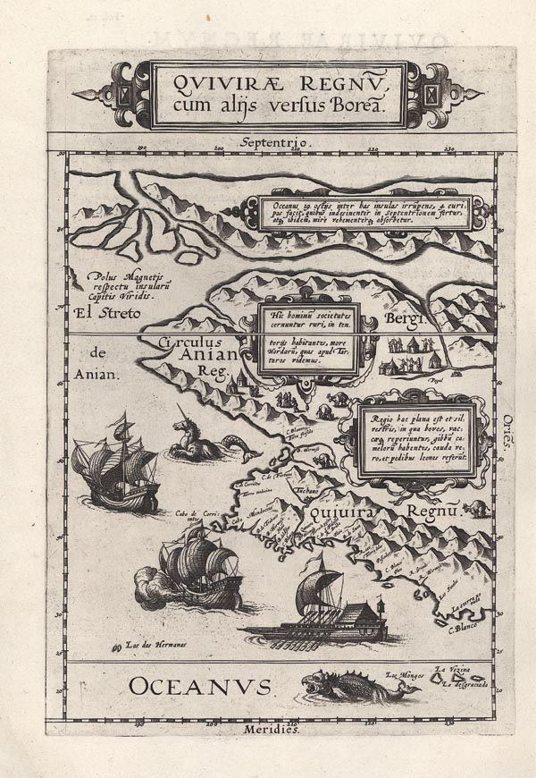
Quivirae Regnu(m), cum aliis versus Borea(m).
1593 Antwerpen143. árverés / 172.
Kikiáltási ár: 1 600 000 Ft Leütési ár: 1 600 000 FtÉszak-Amerika nyugati partjának Cornelis de Jode által készített regionális térképe, amely egyben Alaszka első, nyomtatásban megjelent ábrázolása. Egyetlen alkalommal jelent meg, de Jode Speculum Orbis Terrae című művének második kiadásában. Alkotója Plancius 1592-ben kiadott világtérképét tekintette térképészeti alapnak. De Jode a szárazföld belsejébe kartusokban elhelyezett magyarázó szövegeket illesztett, hogy kitöltse a kora hiányos földrajzi ismeretei miatt keletkezett üres területeket. Ahogy Burden bibliográfiájában leírja: "A belső területek részletei a korabeli hiedelmek és legendák széles skáláját tükrözik, csupán a kontinens partvonalának forrása volt közvetlen tapasztalaton alapuló tudás." A kontinens nyugati részét az Északi-sarktól a Ráktérítőig mutatja be. Megjeleníti a korabeli feltételezések (és Mercator híres, 1569-es világtérképe) szerint az Északi-sarkot körülvevő szigetek részeit, a legendák Északnyugati átjáróját, az Ázsia és Amerika közé képzelt Anian-szorost, ahol megnevezi a "Capitis Viridis" szigetet, mint az északi mágneses pólus helyét. A lapot a tetején és az egyéb belső helyeken található díszes kartusokon kívül a művész mítikus tengeri szörnyekkel, hajókkal, illetve bennszülött falvak és őshonos állatok képeivel illusztrálta. A leírásokban is tatár stílusú — sátrakban lakó — hordákként festi le az őslakosokat, valamint említést tesz a bölényekről, mint olyan marhafajtáról, aminek púpja van, mint a tevének és a belső sík vidékeken honos. A lap verso-ján rövid latin nyelvű magyarázó szöveg olvasható.
Mérete: 235 x 345 (285 x 435) mm.
Tisztított példány. Paszpartuban.
Cleaned copy.
Dimensions: 235 x 345 (285 x 435) mm.
