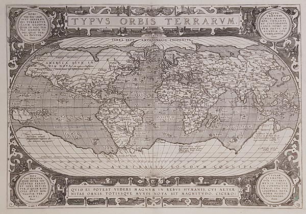
Typus Orbis Terrarum.
1592 Antwerpen145. árverés / 168.
Kikiáltási ár: 950 000 Ft Leütési ár: 950 000 FtRézmetszetű világtérkép, amely Abraham Ortelius Theatrum Orbis Terrarum című híres munkájának 1592-es, latin nyelvű kiadásában jelent meg. A legismertebb ilyen témájú ábrázolások egyike. Az Apianus-féle térképeken megszokott ovális vetületen — középpontban az Atlanti-óceánnal — ábrázolja a kontinenseket, térképészetileg pedig Gerard Mercator (lásd árverésünk 178. és 179. tételeit), Giacomo Gastaldi és Diego Gutiérrez munkáira támaszkodik. Darabunkon — amely a metszet harmadik állapota — javítottak Dél-Amerika partvonalán, és feltüntették a Salamon-szigeteket. Bár Kalifornia már félszigetként szerepel, a kor földrajzi tévedései is felfedezhetők: többek között a hatalmas kiterjedésű déli kontinens (amely a Tűzföldet is magába foglalja), az északi — ismeretlen — földrész, az attól délre fekvő Északnyugati átjáró, illetve Japán, Új-Guinea, a Salamon-szigetek és a délkelet-ázsiai szigetvilág találgatásokon alapuló megjelenítése. A lapot metszője, Franz Hogenberg egy gályával és tengeri szörnyekkel illusztrálta, valamint több kartussal díszítette, amelyek egyikében a mű címe, a többiben pedig klasszikus szerzőktől (Cicero, Seneca) származó idézetek találhatók. A hátoldalon latin nyelvű szöveg olvasható. Ortelius művét az első modern atlaszként tartják számon, amely egységes formátumú térképlapokat és azokhoz tartozó ismertető szövegeket tartalmazott (a korábban megjelent művek egybekötött térképgyűjtemények). 1570 és 1612 között 31 kiadást ért meg, amelyekhez a vásárlók 7 nyelven juthattak hozzá. A nyomólemezeket az évek során módosították és az aktuális földrajzi felfedezésekkel egészítették ki, az összeállítást pedig további térképlapokkal is bővítették.
Mérete: 355 x 490 (430 x 530) mm. Hibátlan, tiszta példány. Paszpartuban.
Ortelius’ work is considered as the first modern atlas containing uniform map sheets with introductory text bound together. 31 editions were published between 1570 and 1612 in 7 languages. The plates were modified and amended depicting the new geographical discoveries and the compilation also had been expanded with several new maps.
Fine, clear copy.
Dimensions: 355 x 490 (430 x 530) mm.
