Ugrás a tartalomra

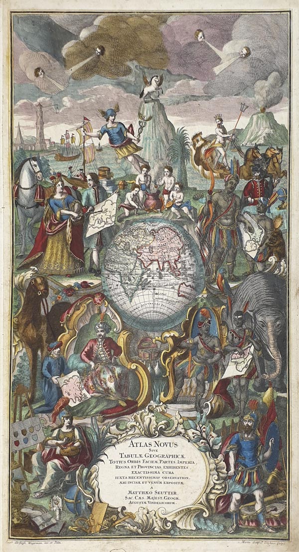
Atlas Novus Sive Tabulae Geographicae...

A mű címe
Atlas Novus Sive Tabulae Geographicae...
Augusta Vindelicorum, Matthaeus Seutter 1t. (színezett rézmetszetű díszcímlap)+92 színes térk.+1t. (táblázat)+(2)p. (kéziratos tartalommutató) Javított, korabeli bőrkötésben. Egy lapon (Silesiae Ducatus) nagy méretű, barnás elszíneződéssel.
150. árverés / 139.

Kikiáltási ár: 5 000 000 Ft
Leütési ár: 5 000 000 Ft

Georg Matthaeus Seutter által kiadott világatlasz, amely 92 kézzel számozott térképet és egy távolságkereső táblázatot tartalmaz. Seutter Nürnbergben töltött tanulóévei alatt Johann Baptist Homann-nál ismerte meg a térképkészítés műhelytitkait, majd visszaköltözött szülővárosába, Augsburgba, és Jeremias Wolff metszője lett. 1707-ben alapított saját nyomdát és korának egyik legjelentősebb kiadójává vált. Az atlasz első -- 16 lapos -- kiadása 1720-ban jelent meg. Az ezt követően közreadott példányokat a kiadó a vásárló igényei szerint állította össze. Tételünk a kézzel írt tartalomjegyzék alapján teljes, annál eggyel több táblát tartalmaz, amelyen európai városok közötti távolságokat tartalmaz táblázatos formában (Curioser Städt-Zeiger). A térképek -- amelyek főként Homann, Guillaume Delisle és Nicolas de Fer korábbi munkái alapján készültek -- megjelenítik a csillagos eget, a Földet, a földrészeket, az európai országokat, hercegségeket és püspökségeket, néhány amerikai területet (New York -- New Jersey -- Pennsylvania, Kanada), Törökországot, a Szentföldet, valamint Jeruzsálem és Freiburg városát. Három további lap hadászati ábrákat mutat be. A gyönyörűen kidolgozott címlapot -- amelyet (a kartus módosítását követően) Seutter halála után veje, Tobias Conrad Lotter is felhasznált -- Jacob Christoph Weyerman tervezte és Martin Gottfried Grophius metszette. A középpontjában a földgömb keleti féltekéje látható, körülötte a négy földrész képviselőjével és vázlatos térképével. A korabeli színezésű térképlapok gazdagon illusztráltak, allegorikus jelenetekkel és látványos barokk kartusokkal díszítettek.

World atlas published by Georg Matthaeus Seutter including 92 hand-numbered maps and a distance indicating chart. Seutter spent his apprenticeship in Nuremberg, where he got to know the secrets of cartography from Johann Baptist Homann, then moved back to his hometown, Augsburg and started to work as Jeremias Wolff's lithographer. In 1707, he established his own press and became one of the most significant publishers of his age. The first - 16-page - edition of the atlas was issued in 1720. The following copies were compiled by the publisher according to the customer's demands. Based on the handwritten table of contents, our item is complete and includes an additional chart, which shows the distances between European cities in a table form (Curioser Städt-Zeiger). The maps - prepared mainly on the basis of Homann's, Guillaume Delisle's and Nicolas de Fer's earlier works - present the starry sky, the globe, the continents, the European countries, duchies and episcopates, some American territories (New York - New Jersey - Pennsylvania, Canada), Turkey, and the Holy Land as well as the cities of Jerusalem and Freiburg. Three more sheets offer strategical depictions. The beautifully elaborated title page - which had also been used (after the modification of the cartouche) by Seutter's son-in-law, Tobias Conrad Lotter following Seutter's death - was designed by Jacob Christoph Weyerman and engraved by Martin Gottfried Grophius. In the centre, the globe's Eastern Hemisphere is shown surrounded by the representatives and draft maps of the four continents. The contemporary coloured map sheets are richly illustrated and decorated by allegoric scenes and spectacular baroque cartouches.
Restored, contemporary leather. With a larger brownish discolouration on one sheet (Silesiae Ducatus), otherwise clear maps.