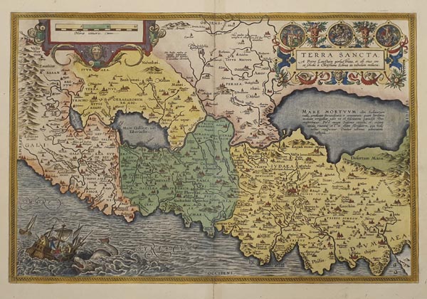
Terra Sancta, a Petro Laicstain perlustrata, et ab eius ore et schedis a Christiano Schrot in tabulam redacta
1595 Antwerpen152. árverés / 166.
Kikiáltási ár: 250 000 FtAzonosító
99614
A Szentföld korabeli színezésű, rézmetszetű térképe, amely Abraham Ortelius „Theatrum Orbis Terrarum” című híres munkájának latin nyelvű kiadásában jelent meg. A mű Christian Sgrothen által készített és 1570 körül közreadott, 9 lapból álló térkép alapján született, amelyet a címben is említett Petrus Laiksteen 1566-os szentföldi útjának térképészeti forrásait felhasználva rajzolt meg az alkotó. Metszője a bal alsó sarokban a Jónást elnyelő cethal jelenetével illusztrálta, valamint két kartussal díszítette munkáját, amelyekben a mű címe (felette Jézus életútját ábrázoló vignettákkal) és a vonalas aránymérték található. A hátoldalon latin nyelvű magyarázó szöveg olvasható.
Contemporary coloured map of the Holy Land published in the 1592 Latin edition of Abraham Ortelius’ „Theatrum Orbis Terrarum”. Based on a 9-sheet map of Christian Sgrothen (published around 1570), who cartographically derived the depiction on the sources from Petrus Laiksteen’s regional visit in 1566. The engraver illustrated his work with the scene of Jonas and the whale and added two embellished cartouches containing the title of the map (and additional vignettes of Jesus’ life at the top) and the bar scale. Latin text on the back.
Dimensions: 370 x 505 (420 x 540) mm. Fine copy with slight toning along centrefold.
Dimensions: 370 x 505 (420 x 540) mm. Fine copy with slight toning along centrefold.
Mérete: 370 x 505 (420 x 540) mm. A hajtásvonal mentén minimális elszíneződéssel. Paszpartuban.
