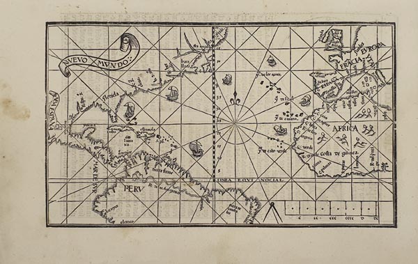
Amerika és az Atlanti-óceán rendkívül ritka, fametszetű térképe, Pedro de Medina „Arte de Navegar” című munkájának első, spanyol nyelvű kiadásából. A munkát az első hajózással kapcsolatos, Spanyolországban publikált összefoglaló értekezésként és a navigációs irodalom mérföldköveként tartják számon. A szerző nemcsak a korabeli forrásokat – többek között Hernando de Soto felfedezéseit – használta a terület feltérképezéséhez, hanem saját megfigyeléseit is papírra vetette, amelyeket Hernán Cortés amerikai útja alatt végzett. Rengeteg olyan, a tengeri hajózást segítő információt rögzített a térképlapon, mint a 16 loxodróma (a navigálást egyszerűsítő egyenesek, amelyek segítségével bár egyszerűbb volt a megfelelő irány rögzítése, de hosszabb ideig tartott az út) és a VI. Sándor pápa által az 1494-es tordesillasi szerződésben megállapított – a világ kolonizációját szabályozó – demarkációs vonal. Gályákkal illusztrálva felvázolta a Spanyolország és Amerika közötti kereskedelmi útvonalakat, amely szerint délnyugat felé indultak, és a Golf-áramlatot kihasználva tértek vissza a hajók. Az áramlat ilyen korai ábrázolása azért meglepő és egyben jelentős is, mert Európa gyarmatosító országainak nagy része csak 200 évvel később fedezte fel annak fontosságát. A lap térképészeti újdonságokban is bővelkedik, hiszen itt jelenik meg elsőként a Mississippi (Rio Spiritu Santo néven, „R. spu. s.” jelzéssel) folyó torkolata és a Szent Lőrinc-öböl. Közép-Amerika partvonala kifejezetten pontos, és a Yucatánt is – helyesen – félszigetként ábrázolta. Névrajzában – a legkorábbi említések egyikeként – mai
megnevezéssel tünteti fel Floridát, Mexikót, Perut és az Amazonast. A metsző a címszalagot a térképmező bal oldalára
– Amerika feltérképezetlen területére – helyezte, középre szélrózsát, a jobb alsó részre pedig aránymértéket rajzolt. Hátoldalán spanyol nyelvű szöveg található.
Tételünk páratlan ritkaságát bizonyítja, hogy az elmúlt 40 évben mindössze kétszer szerepelt árverésen.
Our copy is extremely rare as it was only two times on auction in the past 40 years.
Dimensions: 145 x 245 (195 x 300) mm. With some small light stains at the left side.
