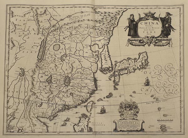
China Veteribus Sinarum Regio nunc Incolis Tame dicta
1634 AmszterdamAuction 152 / 173.
Starting price: HUF 100 000Kína, Japán, Korea és a Fülöp-szigetek északi részének rézmetszetű térképe, amely Willem Janszoon Blaeu „Theatrum Orbis Terrarum, sive Atlas Novus” című munkája 1635-ös, latin nyelvű kiadásának második kötetében jelent meg. A lap számos kartográfiai tévedést jelenít meg, így Koreát szigetként ábrázolja, a japán Hokkaidó pedig hiányzik róla. Indiában viszont feltüntet egy nem létező „Chiamay Lacus”-nak nevezett tavat, amelyből több folyó is táplálkozik. A képen két díszes kartus közül az egyik a címmezőt, a másik Theodor Bas-nak, a Holland Kelet-Indiai Társaság akkori igazgatójának szóló ajánlást tartalmazza (fölötte gondosan kidolgozott címerrel és a kiadók, Joan és Cornelis Blaeu névaláírásával). A térképmezőt metszője európai gályákkal és dzsunkákkal díszítette, valamint északnyugaton a kínai Nagy Fal is látható. A hátoldalon latin nyelvű szöveg olvasható.
Dimensions: 410 x 495 (460 x 530) mm. Fine, clear copy.