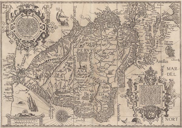
Delineatio omnium orarum totius Australis partis Americae, dictae Peruvianae, á R. de la Plata, Brasiliam, Pariam...
1596 Amszterdam143. árverés / 178.
Kikiáltási ár: 1 300 000 FtDél-Amerika Jan Huygen van Linschoten nevéhez köthető, rendkívül dekoratív, rézmetszetű, nyugat-keleti tájolású tengerészeti térképe, amely Petrus Plancius munkája alapján készült. A portolántérképek hatása (lásd árverésünk 175. tételét) erősen érződik a megformáláson, bár itt csak egy irányvonal-csomópontot jelenítettek meg, a La Plata torkolatának közelében. Északon Floridától egészen a Magellán-szorosig — az Antillák, sőt a Tűzföld egy részére is kiterjedően, amelyet akkoriban a déli kontinens részének gondoltak — mutatja be a partvidéket, minden ismert kikötőt, sziklát és homokpadot feltüntetve. A két díszes kartusban a bemutatott térségek felsorolása olvasható: a bal felső sarokban latinul (a metsző, Arnold Florent van Langren nevével), jobb oldalt alul pedig hollandul. A keret alsó részéhez kapcsolódó kartusban vonalas aránymérték látható. A szárazföld belsejének ábrázolása távolról sem pontos (kitalált folyókat és hegyeket is láttat), de a partvidék ezen a lapon is a legmesszebbmenőkig kidolgozott (még a Tűzföldön is), bár a földrész alakja láthatóan nem a valóságot tükrözi. Az eltérés a hosszúsági körök meghatározásának nehézségével, illetve a terület — főleg a délnyugati partvonal — viszonylagos felderítetlenségével magyarázható. A gazdagon illusztrált lapot készítője gyönyörű szélrózsával, tengeri és szárazföldi élőlényekkel (köztük egy szfinx-szerű, csíkos farkú lénnyel), bennszülöttekkel, gályákkal díszítette, valamint megörökített egy kannibál lakomát is.
Mérete: 405 x 560 mm.
Restaurált, erősen körülvágott példány. Paszpartuban.
Professionally restored copy with narrow margins.
Dimensions: 405 x 560 mm.
