Ugrás a tartalomra

Haemisphaerium sceno graphicum Australe coeli stellati et terrae

A mű címe
Haemisphaerium sceno graphicum Australe coeli stellati et terrae
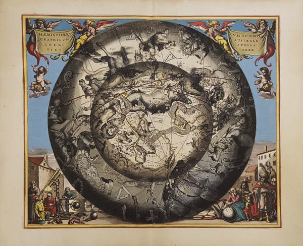
Map of the Southern Sky, illustrating the constellations of the Southern Hemisphere by Andreas Cellarius. Published in his best known work – Harmonia Macrocosmica –, first issued in 1660 by Jan Jansson, as a supplement to Jansson’s Atlas Novus. The map lets the constellations be seen as if it would be from the outer space because the projection is based on the theory of Petrus Plancius. The chart includes the most recently observed constellations – which could only had been seen on voyages to the deep southern latitudes: like Corona Australis, Ara, Dorado, Pavo, Grus, Tucana, Apus, Chamaeleon, Southern Cross (Crux) – and commonly known zodiac signs as well (Pisces, Taurus, Sagittarius, Aries, Aquarius). The celestial hemisphere in the lower corners is surrounded by an allegorical scene sho
141. árverés / 183.

Kikiáltási ár: 800 000 Ft
Leütési ár: 850 000 Ft

Ritka, a déli égboltot ábrázoló, Andreas Cellarius által készített rézmetszetű csillagtérkép. A lap 1660-ban jelent meg Cellarius utolsó (egyben leghíresebb), Harmonia Macrocosmia című munkájában, amelyet Jan Jansson adott ki Atlas Novus című műve kiegészítéseként. A csodaszép ábrázolás a konstellációkat nem földi nézőpontból jeleníti meg, hanem úgy, ahogyan a világűrből lennének láthatóak (e vetület Petrus Plancius elméletén alapult). A csillagképeken túl a földgömbön a déli kontinens -- a Terra Australis Incognita --, továbbá Afrika és Amerika részei is feltűnnek. A lapot az is különösen érdekessé teszi, hogy korának legutóbbi felfedezéseit felhasználva olyan csillagképeket is bemutat, melyek a déli félteke égboltján csak a legdélebbi szélességi körökről figyelhetőek meg (ilyenek például a Déli Korona, az Oltár, az Aranyhal, a Páva, a Daru, a Tukán, a Paradicsommadár, a Kaméleon és a Dél Keresztje), de az alkotó ezeken kívül ismert konstellációkat -- köztük 5 zodiákus jegy képét (Halak, Bika, Nyilas, Bak, Vízöntő) -- is megjelenített. Az éggömböt övező részen alul két jelenetben mutatja be a kor legmodernebb eszközeit, melyekkel az asztronómiai megfigyeléseket végezték, felül a cím körül pedig mitikus lények illusztrációi láthatók. Mérete: 430 x 505 (500 x 605) mm.

Map of the Southern Sky, illustrating the constellations of the Southern Hemisphere by Andreas Cellarius. Published in his best known work – Harmonia Macrocosmica –, first issued in 1660 by Jan Jansson, as a supplement to Jansson’s Atlas Novus. The map lets the constellations be seen as if it would be from the outer space because the projection is based on the theory of Petrus Plancius. The chart includes the most recently observed constellations – which could only had been seen on voyages to the deep southern latitudes: like Corona Australis, Ara, Dorado, Pavo, Grus, Tucana, Apus, Chamaeleon, Southern Cross (Crux) – and commonly known zodiac signs as well (Pisces, Taurus, Sagittarius, Aries, Aquarius). The celestial hemisphere in the lower corners is surrounded by an allegorical scene showing the most modern devices for astronomical observations, and at the top, around the title mythical creatures are depicted.
Dimensions: 430 x 505 (500 x 605) mm.