Ugrás a tartalomra

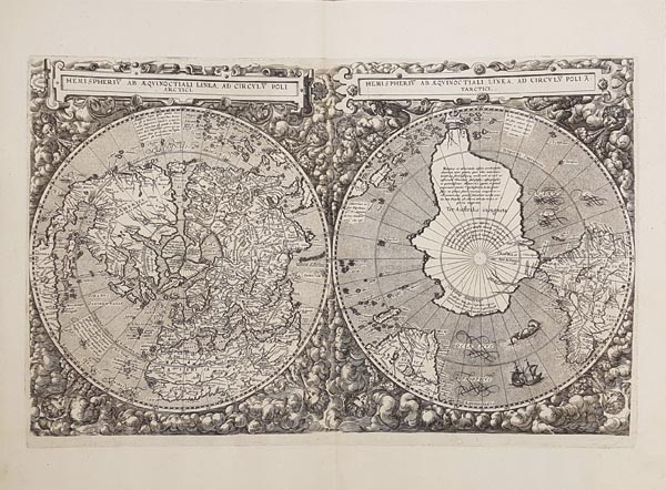
Hemispheriu[m] ab Aequinoctiali Linea, ad Circulu[m] Poli Arctici -- Hemispheriu[m] ab Aequinoctiali Linea, ad Circulu[m] Poli A[n]tarctici.

A mű címe
Hemispheriu[m] ab Aequinoctiali Linea, ad Circulu[m] Poli Arctici -- Hemispheriu[m] ab Aequinoctiali Linea, ad Circulu[m] Poli A[n]tarctici.
Rare, double-polar projection world map. Appeared only in the second – and final – edition of de Jode’s Speculum Orbis Terrarum, published in Antwerp, 1593. One of most spectacular maps of the 16th century (it was Rodney Shirley’s choice for the dust jacket of his bibliographical work). Following Gerard de Jode’s death Cornelis did not use the cordiform projection preferred by his father, but he employed a similar border scheme of windheads and clouds. He relied primarily on the more recent 1581 map by Guillaume Postel and a set of anonymous gores from 1587, resulting in several unusual delineations. In the Northern hemisphere he also represented the Strait of Anian separating America and Asia, and the Northwest Passage according to the contemporary assumptions and even the Terra Australis
141. árverés / 179.

Kikiáltási ár: 5 000 000 Ft
Leütési ár: 6 500 000 Ft

Ritka rézmetszetű világtérkép, amely a két félgömböt sarki vetületeken ábrázolja. Kizárólag Cornelis de Jode Speculum Orbis Terrarum című művének 1593-as, antwerpeni második kiadásában jelent meg, és a XVI. század leglátványosabb térképei között tartják számon (nem véletlenül használta Shirley is bibliográfiai művének borítóján). A lap Gerard de Jode halála után készült el, és bár fia eltért az általa kedvelt – szív alakú – vetülettől, továbbra is szél-fejekkel és felhőkkel gazdagon díszített kerettel övezte azt. Kartográfiai munkája során elsősorban Guillaume Postel 1581-es térképére, és egy ismeretlen eredetű 1581-es földgömbszelvény-kiadásra támaszkodott, ami szokatlan körvonalakat eredményezett (az egyenlítőhöz közeledve a felszíni alakzatok kiszélesednek). Az északi féltekén a korabeli feltételezések szerint Amerikát és Ázsiát elválasztó Anián-szorost és az északnyugati átjárót is feltüntette. A déli félteke nagy részét elfoglaló „Terra Australis Incognita”-t – amely keleten egészen az indonéz szigetvilágig terjed – is az akkoriban felállított hipotézisek alapján rajzolták meg. Mérete: 330 x 530 (420 x 575) mm. Paszpartuban.

Rare, double-polar projection world map. Appeared only in the second – and final – edition of de Jode’s Speculum Orbis Terrarum, published in Antwerp, 1593. One of most spectacular maps of the 16th century (it was Rodney Shirley’s choice for the dust jacket of his bibliographical work). Following Gerard de Jode’s death Cornelis did not use the cordiform projection preferred by his father, but he employed a similar border scheme of windheads and clouds. He relied primarily on the more recent 1581 map by Guillaume Postel and a set of anonymous gores from 1587, resulting in several unusual delineations. In the Northern hemisphere he also represented the Strait of Anian separating America and Asia, and the Northwest Passage according to the contemporary assumptions and even the Terra Australis Incognita that occupies a large part of the Southern hemisphere — and that expands up until the Indonasian islands in the east — was drawn on the basis of hypotheses of the time.
Dimensions: 330 x 530 (420 x 575) mm.