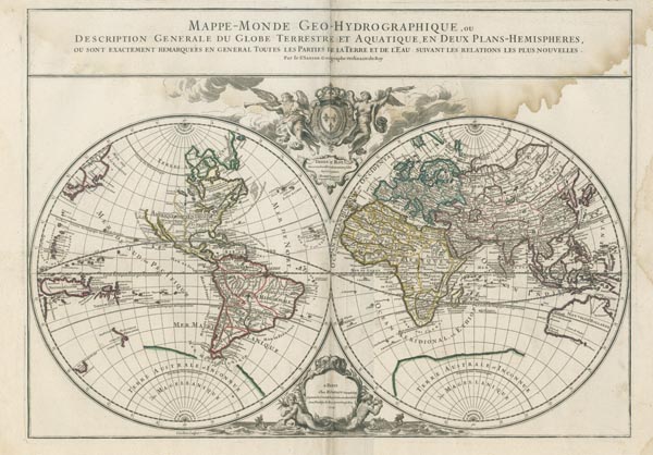
Mappe-Monde Geo-Hydrographique, ou Description Generale du Globe Terrestre et Aquatique en Deux Plans-Hemispheres...
1719 Párizs155. árverés / 171.
Kikiáltási ár: 150 000 FtNicolas Sanson rézmetszetű világtérképe, amely kettős félgömb alakú vetületen — középpontban az Atlanti-óceánnal —, korabeli határszínezéssel ábrázolja a kontinenseket. Darabunkon — amely a metszet egy késői állapota és az Alexis Hubert Jaillot által kiadott "L'Atlas Francois" 1719-es kiadásában jelent meg — Kalifornia már módosítva: félszigetként szerepel. Az alkotó félbehagyott partvonalakkal, csonka kontinens-ábrázolásokkal érzékeltette a kor térképészeti bizonytalanságait. A metsző, Louis Cordier a térképmező fölé középre angyalokkal övezett királyi címert helyezett, amely alatt az ajánlás, a lap alján lévő kartusban pedig az impresszumadatok szerepelnek.
Mérete: 460 x 645 (520 x 740) mm. Felül nagy méretű, jobbra kisebb vízfolttal és két (javított) szakadással.
Dimensions: 460 x 645 (520 x 740) mm. Original outline colour. Large water stain at the top and smaller on the right side. Two small tears previously restored.
