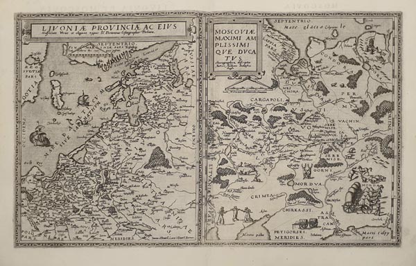
Livoniae Provinciae... -- Moscoviae Maximi Amplissimique Ducatus
1593 Antwerpen152. árverés / 162.
Kikiáltási ár: 300 000 FtAzonosító
99719
Lívföld és a Moszkvai Nagyfejedelemség ritka, Gerard de Jode által készített kettős rézmetszetű térképe, amely a „Speculum Orbis Terrae” második kiadásában jelent meg. Az orosz lap Anthony Jenkinson 1562-es munkája, Livónia pedig Jan Portant 1573-as műve alapján készült. A metszők – Jan és Lucas van Deutecum – a területeket közös, kétablakos keretbe, de önálló kartussal rendelkező, külön térképmezőkbe helyezték, illusztrációként pedig gályákat, őshonos állatok vignettáit és életképeket alkalmaztak. Hátoldalán latin nyelvű szöveg található.
Rare double map of Livonia and the Grand Duchy of Moscow (Muscovy) by Gerard de Jode, published in the second edition of de Jode’s „Speculum Orbis Terrae” in 1593. The Russian part is based on Anthony Jenkinson's 1562 map, while the Livonian one on Jan Portant's 1573 cartographical work. The engravers – Jan and Lucas van Deutecum – placed the individual map fields in the same – divided – ornamental frame, but added separate cartouches to each one, and illustrated their work with galleons, native animals and scenes from the life of the local inhabitants. Latin text on the back.
Dimensions: 335 x 510 (415 x 555) mm. Fine, clear copy.
Dimensions: 335 x 510 (415 x 555) mm. Fine, clear copy.
Mérete: 335 x 510 (415 x 555) mm. Hibátlan, tiszta példány. Paszpartuban.
